Tampa Plans Streets and Lots for a Growing Town
1846 — Hillsborough County commissioners sought survey proposals for 40 acres of streets and town lots, an early step toward Tampa’s planned growth.
By Wm. E. McMullen II
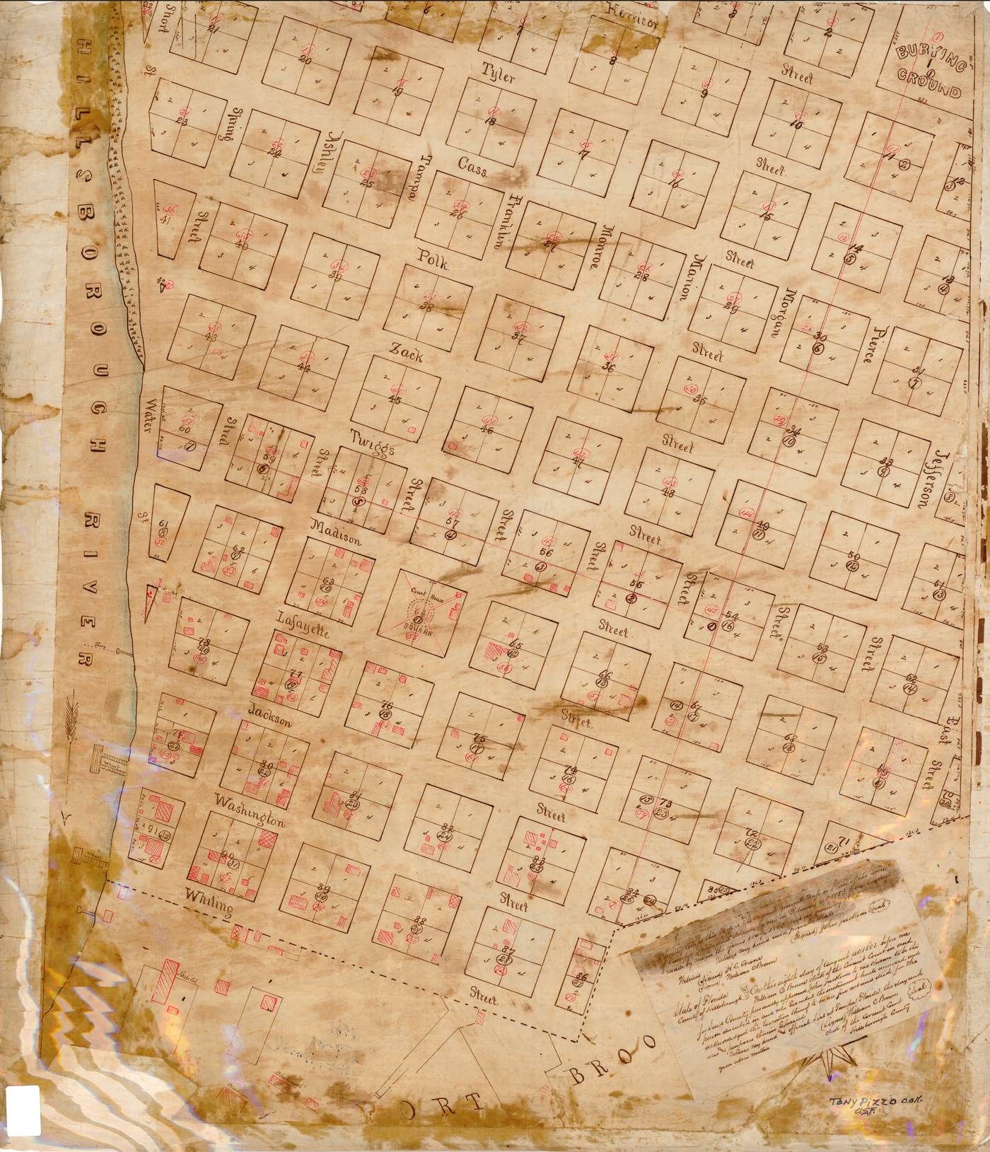
Forty Acres and a Practical Question
On October 19, 1846, Hillsborough County commissioners took up a question that would help shape Tampa: how could forty acres be divided into streets and town lots? They directed the board's president to seek terms from at least two surveyors. The wording survives in a 1937 Works Progress Administration historical sketch, which quotes the earlier county action. It was a request for proposals, not a declaration that a new city had suddenly appeared.[1]
There is something revealing about the modest scale of the request. The commissioners were dealing with a tract of land and the practical work of laying it out. Before streets could become familiar addresses, someone had to decide where they would run, how lots would be measured, and how the settlement's public needs would fit into the plan.
From a Settlement to a Planned Village
Tampa's growth was closely tied to Fort Brooke and the surrounding civilian settlement. The Tampa Bay History Center explains that an earlier attempt to establish a town plat had run into the problem of including military land. By late 1846, county officials anticipated a reduction in the fort's reservation and wanted a surveyed village whose lots could be sold to help finance a courthouse.[2]
A courthouse meant more than an imposing building. It provided a place for public business and the records that made property transactions and county administration possible. The proposed streets and lots belonged to that same effort to give the growing community a more durable framework.
The Surveyor and the Map
John Jackson became an important figure in that surveying work. The History Center connects him with the village plat produced from the late-1846 effort. The later map reproduced above, held by the University of South Florida Libraries and attributed to Jackson, shows the resulting world of numbered blocks, individual parcels, streets, and buildings beside the Hillsborough River.[2][3]
The dates deserve care. USF catalogs this map as an 1853 creation and describes it as documenting the period 1847–1850. It is therefore useful evidence of early Tampa's layout, but it is not a map made at the October 19 meeting. Nor does the commissioners' request establish that every street or lot was completed that day.
What Lines on Paper Could Do
A plat turns a broad description of land into a pattern people can discuss, transfer, build upon, and record. Its numbered lots make it possible to distinguish one parcel from the next. Its streets show how those parcels connect. On Jackson's map, the river and the settlement's geometry can be examined together, making the relationship between waterways and town planning visible.
Yet the neatness of a map should not be mistaken for a complete picture of life. It does not tell us everything about the people who worked in the settlement, the conditions of their homes, or the area's longer Indigenous history. A street plan answers certain questions exceptionally well while leaving others to different records.
Why October 19 Matters
This anniversary records an early planning decision, rather than Tampa's incorporation. Its importance lies in the ordinary work behind the growth of a town: asking for bids, engaging a surveyor, arranging public space, and keeping records. The much larger Tampa of later generations began, in part, with decisions small enough to fit into a county meeting.
Explore and Discuss
Glossary: Plat — a map dividing land into lots, blocks, and streets. Survey — the measurement and description of land. County seat — the community where a county's main government offices are located.
- Why might county officials seek proposals from more than one surveyor?
- How could selling town lots help provide a public building?
- What can Jackson's map tell us that the meeting account cannot? What does neither source establish?
Sources and Further Reading
- Felix Cannella, Works Progress Administration, Historical Records Survey. Historical Sketch of Hillsborough County, revised April 19, 1937, especially page 2. State Library of Florida, WPA County Histories, Florida Memory. Identifier: wpa_county_history_hillsborough_01.
- Tampa Bay History Center. From La Florida to the Sunshine State! Using Primary Sources to Learn About the Past, 2018, background information for the Village of Tampa map, PDF page 8.
- John Jackson. Cadastral Map of Tampa, 1853. USF Libraries, Tampa Bay Area Map Collection, image 4; identifier U15-1009. Cataloged creation date 1853; documents 1847–1850. Rights statement: No Copyright — United States.
Explore the daily archive: Discover more events that shaped Florida.
Today in Florida History