A Hurricane Floods Tampa Bay Communities
1921 — The October 25 hurricane drove destructive water into Tampa Bay’s waterfront communities.
By Wm. E. McMullen II
When Tampa Bay Came Ashore
On October 25, 1921, a hurricane struck near Tarpon Springs and drove destructive water into Tampa Bay’s coastal communities. The National Weather Service’s anniversary account estimates the storm at Category 3 and describes a storm surge of approximately eleven feet. Homes, docks, seawalls, vessels, and commercial facilities stood in the path of water pushed beyond the ordinary shoreline. The event exposed how closely the region’s growing communities depended on the boundary between land and bay. [1]
The date belongs to a particular hurricane, rather than to a general warning about Florida weather. Contemporary residents faced a storm observed without satellites, weather radar, or modern computer models. Later researchers could examine those observations with tools unavailable in 1921. Reading the event accurately means distinguishing what happened, what people could know at the time, and what later analysis has helped reconstruct.
Why Water Became the Central Danger
A hurricane threatens a coast through more than wind. Storm surge is the rise in water level caused by the storm, driven largely by winds pushing water toward the shore. The resulting flooding can reach places that would ordinarily remain dry. Waves riding on elevated water can then strike buildings and waterfront structures from positions the structures were never intended to withstand. [3]
Around a bay, that process can affect communities separated by considerable distances along the shoreline. The damage is not limited to the location where the storm’s center crosses the coast. Water, wind, shoreline shape, and the storm’s movement interact. A landfall near Tarpon Springs could therefore produce a wider regional disaster rather than a single damaged point on a map.
This distinction helps explain why a hurricane’s category cannot tell the entire story. The category describes sustained wind, while flooding depends on additional conditions. A reader examining the 1921 storm needs both the wind estimate and the account of water invading waterfront neighborhoods. Treating one number as a complete description would hide the mechanism responsible for much of the loss.
A Working Waterfront in the Path
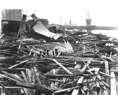
The Weather Service documents severe destruction around Palmetto Beach, Edgewater Park, and the Hendry and Knight Channel. Its account also identifies damaged vessels, including the steamer Favorite and the Thomas B. Garland. The accompanying photographs show commercial terminals and other waterfront facilities affected by the hurricane. [1]
These were places where people worked and moved goods. A damaged dock meant more than a broken structure beside the water. It could interrupt the transfer of cargo between vessel and shore. A stranded or wrecked vessel represented both physical property and a lost means of transportation. When homes and working facilities were damaged together, the problems of shelter and income overlapped.
The bay’s shoreline was consequently an economic landscape as well as a residential one. A disaster affecting that shoreline could disrupt families who lived there, workers whose jobs depended on waterfront activity, and businesses connected to those facilities. Those relationships help explain why photographs of terminals belong in a community history alongside pictures of flooded streets.
Agriculture Beyond the Water’s Edge
The storm’s effects extended inland. The Weather Service reports serious losses to the citrus industry and destruction of crops. That damage connects the hurricane to Florida’s agricultural economy. An orchard could be far from a battered dock yet remain part of the same disaster through exposure to wind, water, and disrupted transportation. [1]
Agricultural losses also have a different time scale from clearing a road. Removing debris can restore access, but it cannot instantly replace a lost harvest. Where productive plants or supporting facilities are damaged, recovery involves the growing season and future work as well as immediate repairs. The anniversary therefore belongs to the history of rural livelihoods as much as urban waterfronts.
The Weather Service’s historical account lists eight confirmed deaths, most associated with drowning, and approximately five million dollars in damage in the currency of the time. Those figures should be attributed rather than treated as perfectly complete modern measurements. They provide a documented scale of loss while leaving room for the limits of surviving records.
Forecasting With Sparse Observations
In 1921, forecasters depended on scattered marine and land reports. They could not watch the storm develop through continuous satellite imagery. A gap in reports represented an actual gap in knowledge, not simply an empty space on a familiar weather application. The Weather Service explains that earlier storm patterns also influenced expectations about where a Gulf hurricane might travel. [1]
That limitation matters when judging the people who faced the event. Knowing a storm’s reconstructed path today does not mean residents had that same information before it arrived. Historical explanation should avoid giving the past a modern forecast after the fact. The practical questions were what warnings reached people, how those warnings were understood, and what actions were possible in the time available.
NOAA’s hurricane reanalysis work revisits older storms using surviving observations and historical evidence. Revised estimates can improve the record, but they remain reconstructions. A category assigned through later study is not necessarily a term that appeared in a newspaper warning before landfall. Keeping the chronology of knowledge separate from the chronology of the storm makes the account more precise. [2]
Photographs as Evidence of Recovery’s Starting Point
The embedded photograph of the Southern Steamship Company and Gulf Terminals belongs to a documented collection credited by the Weather Service to the Tampa-Hillsborough County Public Library System. It preserves a specific part of the damaged waterfront. Its value comes from that identified setting, not simply from the dramatic appearance of wreckage.
A photograph can help establish what a place looked like after the event. It cannot by itself measure every loss or explain every decision made before the storm. Comparing images with weather reports, business records, maps, and personal accounts allows a broader reconstruction. Each kind of evidence contributes something the others may lack.
Why It Matters to Florida
The story also benefits from studying a map at more than one scale. A regional map locates the landfall and bay, while a neighborhood map helps identify damaged streets and working waterfronts. Neither replaces the other. Together they connect the movement of a large weather system to the particular places where its effects were experienced. That movement between regional cause and local consequence is essential to understanding hurricanes as historical events.
The October 25 hurricane reveals the close connections among coastal development, transportation, agriculture, and weather. Tampa Bay’s communities depended on waterfront access, yet that access also placed valuable facilities and homes beside water capable of becoming destructive. The same geography supported opportunity and exposure.
Remembering 1921 is therefore more than reciting a category or a damage figure. It means understanding how a storm disrupted the systems people used to earn a living, travel, and shelter their families. The surviving record gives Florida a historical example of regional vulnerability while showing why careful captions, attributed estimates, and attention to human consequences matter when telling the story of a disaster.
Classroom Connection
Reading Prompt
Before reading: Why might a hurricane damage places far from the point where its center reaches land?
Glossary
- Storm surge
- An abnormal rise in sea level generated by a storm.
- Landfall
- The crossing of a tropical cyclone’s center over a coastline.
- Reanalysis
- A later examination of historical observations to improve estimates of past weather.
- Infrastructure
- Facilities and systems a community depends on, such as docks and roads.
Reading Check
- Where did the 1921 hurricane make landfall, according to the Weather Service?
- Name two kinds of work or property affected by the storm.
Think and Discuss
Why should readers distinguish what forecasters knew in 1921 from what researchers can reconstruct today?
Short Writing Prompt
Describe how waterfront damage could affect both a household and the wider economy. Use two documented details and identify any inference you make.
Teacher Notes and Suggested Answers
The cited account places landfall near Tarpon Springs. Examples include vessels, terminals, homes, seawalls, and citrus crops. Students should separate documented damage from reasoned consequences, and recognize that hurricane categories describe wind rather than the full flooding hazard.
Suggested use: introduce the reading prompt, read the account, check comprehension, then select the discussion or writing task. Adapt vocabulary and response length to the class.
Sources and Further Reading
- National Weather Service, Tampa Bay. 99th Anniversary of the 1921 Hurricane, 2020; historical damage account and image captions.
- NOAA National Hurricane Center. Atlantic Hurricane Database Re-analysis Project: methods and historical revisions.
- National Weather Service. Hurricane Safety Tips and Resources: storm-surge mechanisms and hurricane hazards.
Explore the daily archive: Discover more events that shaped Florida.
Today in Florida History