The Labor Day Hurricane Strikes Florida — Again
September 4, 1935 — Two days after devastating the Florida Keys, the great Labor Day Hurricane of 1935 was not finished with Florida.
On September 4, the same hurricane made a second Florida landfall near Cedar Key, this time as a Category 2 hurricane. Although dramatically weaker than the Category 5 monster that had crossed the Middle Keys on September 2, the storm remained dangerous.
And in 1935, the number attached to a hurricane told only a small part of the story.
Cedar Key was a small Gulf fishing community built close to the water. Buildings were generally less resistant to hurricane winds than modern structures. Communications were limited. Forecasting was primitive by today's standards. And perhaps most importantly, the hurricane carried a danger that people still sometimes underestimate today: water.
Cedar Key: A Gulf Fishing Village
Cedar Key sits in Levy County along Florida's Big Bend, where a collection of low-lying islands reaches into the Gulf of Mexico.
For generations, the community's identity and economy have been closely connected to the Gulf. Fishing, boats, docks and waterfront businesses were not simply recreational features—they were part of everyday life.
That relationship with the water made Cedar Key a natural fishing community. It also made it vulnerable.
When the Labor Day Hurricane approached on September 4, residents were not watching the storm from miles inland. Much of the community's livelihood, transportation and infrastructure existed immediately beside the Gulf.
A hurricane approaching such a community could attack from both directions: wind from above and water from below.
The Category Number Doesn't Tell the Whole Story
Today, hurricane coverage often begins with a familiar question: What category is it?
The Saffir-Simpson Hurricane Wind Scale is useful, but it measures sustained wind speed. It does not tell us how high the storm surge will be.
That distinction matters.
Storm surge is seawater pushed toward the coast by a storm's winds. Its severity depends on much more than hurricane category. Storm size, forward speed, angle of approach, coastline shape and the depth of the water offshore can all affect how much water reaches land.
Florida's Big Bend is particularly susceptible because of its broad, shallow offshore waters. Water driven toward the coast can accumulate rather than quickly dispersing into deep water. And waves can ride on top of the elevated water.
A Category 2 hurricane therefore does not mean a community faces only a “Category 2” water threat.
For people living near the coast, storm surge can be more destructive—and more deadly—than the wind itself.
A More Vulnerable Florida
Florida in 1935 was physically different from the Florida we know today.
There was no modern statewide hurricane-resistant building code. Many homes and businesses, particularly in small coastal communities, were wood-frame structures. Roofs, walls and foundations generally lacked the engineered connections now commonly used to resist extreme winds.
Docks, fishing boats, waterfront buildings, electrical systems and communications infrastructure were especially exposed.
Modern construction cannot make a building hurricane-proof. Storm surge, flooding, waves and extreme winds can still destroy well-built structures.
But stronger roof-to-wall connections, improved foundations, reinforced construction, impact protection and modern flood standards can significantly improve a structure's chances of surviving.
Those protections generally did not exist in Cedar Key in 1935.
The difference is important when reading historical accounts. Saying that a Category 2 hurricane struck a community in 1935 does not mean residents faced the same physical circumstances that residents of a modern coastal community might face today.
Warning a Community in 1935
There was another enormous difference.
There were no weather satellites watching the hurricane from space. There was no Doppler radar showing its circulation. There were no computer forecast models constantly calculating possible tracks. There were no Hurricane Hunter aircraft routinely flying into the storm to measure its structure. There were certainly no smartphones delivering emergency alerts, projected tracks and evacuation instructions directly into people's hands.
Forecasters instead depended heavily upon weather observations from ships, coastal stations and other locations. Barometric pressure, wind observations and reports transmitted through telegraph and radio helped meteorologists determine where a storm might be and where it might go next.
That left enormous gaps.
A hurricane could travel across areas of the ocean where few observations were available. Its exact strength, size and location could be difficult to determine.
Warnings could be distributed through radio broadcasts, newspapers, telephones, telegraph systems and local officials—but only if the information reached them in time and the communications infrastructure continued functioning.
Once telephone or telegraph lines failed, communities could become increasingly isolated.
Residents might know that a hurricane threatened the coast without having anything approaching the detailed information available today: precise forecast tracks, storm-surge maps, evacuation zones, arrival times, wind probabilities and continuously updated emergency instructions.
The Storm That Wouldn't Leave Florida
After crossing the Florida Keys on September 2, the hurricane entered the Gulf of Mexico and curved northward.
Instead of disappearing westward into the Gulf, its path carried it roughly parallel to Florida's west coast.
Communities from Southwest Florida through Tampa Bay and north toward the Big Bend remained threatened by the same storm that had just produced catastrophe in the Keys.
Tampa experienced hurricane conditions as the storm moved north. Heavy rain, elevated tides and strong winds accompanied its passage.
Then the hurricane approached Cedar Key. On September 4, it reached Florida again.
Cedar Key Takes the Blow
The hurricane passed near Cedar Key before moving inland across Florida's Big Bend.
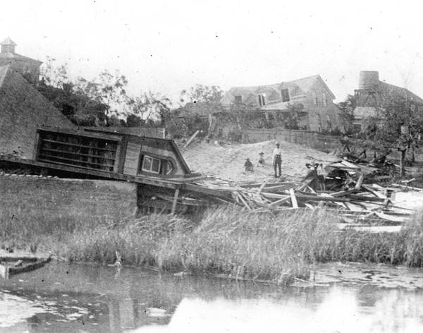
The small coastal community suffered severe damage.
Docks and fishing vessels were battered. Waterfront structures were damaged. Trees and utility lines came down. Homes lost roofs or were heavily damaged.
Three people were killed at Cedar Key.
Historical accounts described the flooding as the community's worst since the devastating Cedar Key hurricane of 1896.
For a fishing community, the destruction extended beyond houses. Damage to boats, docks and waterfront facilities could also mean the destruction of a family's livelihood.
The Gulf provided Cedar Key with its living. On September 4, 1935, that same Gulf became one of its greatest threats.
Destruction Spreads Through the Big Bend
Cedar Key was not alone.
The hurricane continued inland across portions of North Florida while still producing damaging winds and heavy rainfall.
Communities in Dixie and Taylor counties experienced significant effects. Horseshoe Beach suffered severe damage. Trees fell, buildings were damaged and communications were disrupted.
The hurricane that had been extraordinarily intense and relatively compact when it struck the Keys had evolved, but it remained capable of spreading destruction across another large section of Florida.
Meanwhile, the Keys Were Still Searching for the Dead
Perhaps the most extraordinary part of the September 4 landfall was its timing.
Hundreds of miles south, rescue crews were still searching through the wreckage left in the Florida Keys.
The full magnitude of the September 2 catastrophe was only becoming known.
Entire federal work camps occupied by World War I veterans had been destroyed. Homes and businesses had disappeared. Sections of Henry Flagler's Overseas Railway had been washed away. Bodies were still being recovered.
Newspapers were carrying accounts from survivors while the hurricane responsible for the catastrophe was still threatening Florida.
Residents of Cedar Key were preparing for a hurricane while residents of the Keys were still discovering what that hurricane had already done.
Florida was simultaneously experiencing the aftermath and the continuation of the same disaster.
A Hurricane That Changed Florida History
The 1935 Labor Day Hurricane ultimately killed more than 400 people, with the overwhelming majority of the deaths occurring in the Florida Keys.
Its minimum recorded central pressure near Long Key—892 millibars, or 26.35 inches of mercury—made it the most intense hurricane known to have struck the United States when measured by central pressure.
The hurricane destroyed much of the Florida East Coast Railway's Key West Extension. The railway would never be rebuilt, and portions of its route and bridges eventually became part of the developing Overseas Highway.
The deaths of World War I veterans working in federal highway camps also created a national controversy over preparations and evacuation.
But concentrating entirely on the catastrophe in the Keys can obscure another remarkable part of the storm's history.
It struck Florida twice.
One Hurricane — Two Floridas
On September 2, the Labor Day Hurricane devastated the Middle Keys.
On September 4, it reached Florida again near Cedar Key.
The two places could hardly look more different.
One is part of the long tropical island chain stretching toward the Florida Straits. The other is a small Gulf fishing community surrounded by the marshes, shallow waters and islands of Florida's Big Bend.
Hundreds of miles separated them.
For several days in September 1935, however, they were connected by the same hurricane.
Understanding that story requires more than knowing the storm's category.
It requires understanding the buildings people lived in, the information available to them, the difficulty of communicating warnings, the geography of the communities—and the tremendous destructive power of water.
On September 4, 1935, Cedar Key experienced the second Florida chapter of a hurricane disaster that had already changed the state's history.
Sources for Additional Reading
- National Hurricane Center — NOAA — Historical hurricane information and educational resources.
- National Hurricane Center — Storm Surge Overview — Explanation of storm surge and the factors that determine its severity.
- Florida Memory — State Archives of Florida — Original archival record for Cedar Key hurricane photograph RC03829.
- National Weather Service — NOAA — Hurricane hazards, forecasting and preparedness information.